By Sol
The following was written to be Part II of my Grail Tale, the first part of which was published here recently as “How to look for the Grail”. To recap briefly, my entire investigation of that area began by trying to help a friend solve an old murder in the town of Reston, Virginia. Several highly interesting findings from there led me to conclude that my trail of clues also points to nothing less than the old “Templar Grail”.
This portion of our story will deal with specific Geographic Locations, namely the exact place in Virginia where I believe the Grail was hidden as well as several other interesting spots in that area. And we shall also have to follow several numbered Directions on the local map, to explain why I feel that this must’ve been the exact place. So if Geography and generally following numbers on maps is not your thing, you're not likely to enjoy the proceedings too much. Still, this is something which has to be told one day, and I’ll try hard to make it sound as exciting as possible.
Introduction
Before we begin it is first necessary to stress once again, that we are following the Mystical Path here, where things do not work exactly as they do in the "real world". We're looking for the Holy Grail itself after all - something widely believed to be an entirely mythical thing, an invention of people's imagination. Somewhat different Rules of Reason must apply when searching for something like that. For example, one's Intuition would have to play a fairly important part in the search.
This may help explain why it can sometimes seem like I'm being inconsistent with my data, not to say entirely delusional, and my findings possibly make little sense. Particularly on the Path that I suggest that we follow today, you may notice that I'll name some locations and numbers as very pertinent, and will maybe ignore many seemingly no less pertinent places and numbers right near them.
So another very important thing to always keep in mind in that regard, is that the Grail has usually been described in the Lore as basically a "Personal Quest". All these names and numbers may mean one thing to me, and something entirely different to somebody else. The particular "Grail Path" that I followed is one which has Meaning possibly only for myself. Still, when we reach the end here, I think many will agree that it very likely has a lot of meaning for some others as well.
Our Journey will begin by recalling something I mentioned earlier - that many Grail Researchers view the various Names connected with people and places involved in the Grail story as extremely significant. These Names would surely be one of the Big Hints which a modern-day Grail researcher has to work with, seeing as everything else about this subject had been suppressed, hidden, and confused for so long. Taking that into account, here are a couple of additional highly notable coincidences in our Caper, before starting down the actual Trail.
The town of Reston, Virginia, was indeed the first of the post-war “planned suburban Utopias” - but it was very soon joined by others. The first such effort outside of Reston was led by a Baltimore mortgage banker named James Rouse, who launched the highly successful town of Columbia, Maryland in 1964. It's located only about 30 miles to the north-east of Reston and about 20 miles from Langley, and though I haven't looked into this, but perhaps similar "experiments on the population" were being conducted there. (See my “Reston Caper” for details on that.) After all, Columbia is just a few miles away from the famous Fort Meade of the NSA and the nearby "Patuxent Wildlife Refuge", a well-known government biological research center in Maryland.
Several highly interesting coincidences connect Columbia with Reston, for reasons which I haven't fully explored and understood yet. For instance, readers of the Caper will recall that the chief architect of the first buildings in Reston was one James Rossant, a name curiously similar to "James Rouse", founder of Columbia. Both names carry the unmistakable and highly interesting reference to the Rose and to the color Red, both of which are *extremely* pertinent concepts in the Grail Story, according to all the research on which recent books like “The Da Vinci Code” were based.
And of course as we mentioned, "James" is also a most important name in the Grail Tale, being the name of the last king of the Stuart dynasty in England, for whom the “Jacobites” are named. Another fun similarity is that James Rouse, the founder of the Second Model City in the US, was born in the same year as Robert Simon, the founder of the First Model City. Both were born in 1914, the year World War I also officially began.
But this does not exhaust the list of coincidences between Columbia and Reston. Just south of Columbia, MD, passes a main highway known as Maryland Route 32 ("32" being of course a very important number in Masonic Lore.) Going east from there on that Route 32 we round Fort Meade and the Patuxent Refuge, and afterwards intersect with US Highway 50, a road we shall presently examine. But just south of Columbia and of Route 32 lies a town called "Laurel" - and a few miles to the north-west of it is another town called "Fulton".
To remind the readership at this point, my entire Reston Caper Investigation as well as this Grail Tale, began by following information that I got from a person named Laura, who at the time was married to a man named Fulton. And not just any Fulton, but a Macdonald - a name also deeply intertwined with the Stuart Kings and the fate of the Grail in Scotland. (In addition, the towns of Laurel and Fulton are accessible from Columbia by US Highway 29, another significant number for reasons there's no room to go into here.)
So yes, all these are without a doubt very fun coincidences - however, the town of Columbia, MD, actually lies outside of the scope of this particular Quest, and is something that can be researched later for more detail and understanding. But right now we are going back to Reston, Virginia, where my Grail Quest began.
The way I found my Direction from there, was by considering something Laura wrote to me in a letter so long ago that I no longer even have it saved here. She said that one time, as her plane was coming into Dulles International Airport, she saw a totally straight line of lights, pointing basically all the way from Washington DC, past her house in Oakton, and right to the airport. This seemed very significant to her at the time, as if it were some big revelation she was supposed to get. And since this is a person whose judgment I tend to trust in these matters, I decided that it must indeed be very significant for my whole Grail Story.
Highway 50
I looked for Laura's "straight line of lights" on Google Maps - and saw it right away. Anyone can easily find this location on the Maps and see exactly the same thing. Starting near the center of the town of Fairfax, Virginia, just south of Laura's childhood home in Oakton, a road called US Highway 50 becomes straight as an arrow, pointing at about a 30-degree angle towards the northwest. Called also “Lee-Jackson Memorial Highway" and later “John Mosby Highway”, the straight segment passes through the town of Chantilly skirting Dulles Airport on the south, and as you can see below remains totally straight for about another ten miles, until it intersects with US 15 in the town of Aldie (not named on the clickable snapshot from Google Earth below.)

The straight line of Highway 50 from Fairfax to Aldie, Virginia
Well, the reason that US Highway 50 is so straight in that particular segment is immediately obvious to anyone who has studied military history, and it’s one of those “open secrets” that are widely known but not often mentioned. There are many places like that around sensitive locations, notably in the DC area. This is of course one of them "Alternate Landing Strips", to be used in times of various emergencies, when the regular airport had been put out of commission or is otherwise unavailable. Any nation which is “prepared for war” has these, and there are plenty of them in my own country as well.
But these landing strips are something relatively new, in use only from the start of the Aviation Age in the past century and certainly not in the early days of Colonial Virginia, which is the relevant period for our Grail story. So this is not the reason I thought that US 50 was such a significant road. No, I decided that it has to be vital in the Grail Quest because of its very number, 50.
I won't go into details here, but Fifty is a most important number in all Western mystical lore, going back to ancient Sumer, Egypt, and Israel. In Sumer it was the number of the Head God of Earth - in their case the god Enlil, who was known as the "God of Fifty". In the Hebrew Bible, 50 is of course the highly separate Jubilee Year, when many things get to be done and renewed. I'll stop the recount here, but the list is really quite long. Certainly long enough to convince me that it could not have been a coincidence at all, that this particular number was assigned to a road passing right through the center of the Reston Caper and my Grail Story.
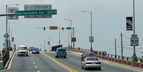
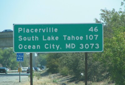
I eventually followed Highway 50 along its whole way across the US. This is in fact the longest Federal road in the country, stretching continuously for over 3000 miles coast to coast - starting in Ocean City on the Delmarva Peninsula in Maryland and the Atlantic coast, and ending in Sacramento, California, just short of the Pacific. Along the way it passes barely fifty miles north of Crestone, Colorado, and through several other important locations. In many places it follows closely along the famous Mason-Dixon Line, as if cutting the country into two halves. I would venture a guess that this must've been the original proverbial road that led "from sea to shining sea".
Highway 50 road sign in Ocean City, Maryland
Highway 50 road sign in Sacramento, California
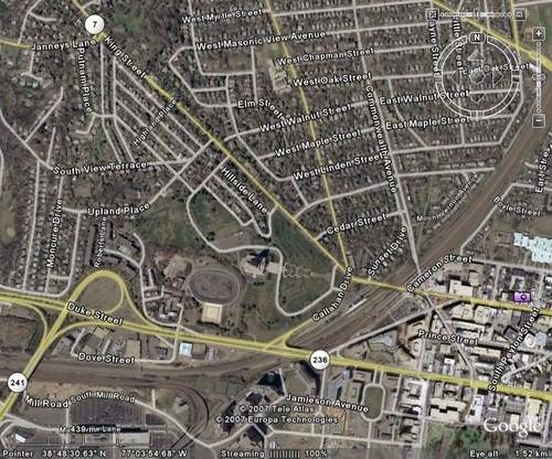
But before we go that far, and having determined that this highway must be very important in our story somehow, I started closely looking at it around the Reston area. The mentioned straight segment begins in the borough of Fairchester in the town of Fairfax, and goes westwards past Reston and Dulles airport. East of there however, it leads nearly horizontally to what appears to be possibly the most important crossroads in the old US - the famed Seven Corners, between the old towns of Falls Church and Sleepy Hollow. This intersection was getting a lot of mention in the news a few years ago, as one of the locations where that crazy "Maryland sniper" had struck.
Map of the Seven Corners Area
It's not necessary to spell out again the ancient mystical significance of the number Seven, and especially for myself. For one thing - our Seventh month today is July, but it was the First month in the Egyptian Calendar and called the Month of Thoth. And Thoth is of course the "entity" whom I hold responsible for being nothing less than the "creator" of the Grail. July is the month in which the American Nation was born as well, as celebrated to this day. The French Revolution is celebrated in the same month of July, ten days later. It is also the month in which I myself was born.
Upon looking at the location of Seven Corners, one immediately notices that Virginia Route 7 crosses it at an angle, intersecting with Highway 50. Another Seven, so it must be important. If you dial that location on Google Maps and follow Route 7 south and east from there, you will see its beginning in the town of Alexandria, a few miles down from the above map. It starts by branching off US Highway 1 - of course also a very significant number.
The Alexandria Triangle and Compass
Route 7 begins in Alexandria going due west from Highway 1 as King St., and then it angles sharply north, at a curious little place called the George Washington Masonic Monument. A place which seems obvious would have to be a MOST significant marker for any "Grail in America" inquiry, and thus a very fitting Anchor Point in our Quest for the "Masonic Grail".
Angling from the same place and enclosing the Masonic Monument in a type of "triangle" between the two roads, is Virginia Route 236. The number 236 would likely be meaningless to most people, but holds much significance to those like myself, who have followed Gary Osborn's ideas and articles about the"23.5 degrees". There we have learned that the offset angle of both the Earth's axis and the King's chamber in the Great Pyramid is, in fact, exactly 23.6 degrees. This is without a doubt a very meaningful number in Masonic and other occult lore.
And here's the trick I urge everyone to try on Google Maps or Earth. If you close in on the Washington Masonic Monument on the satellite images like the ones below, you'll see a huge Masonic square-n-compass painted right on their very front lawn. Now zoom way out, and you will see that Routes 7 and 236 move away from each other at that point, at a similar angle as the compass on the design.
All in all, with the conjunction of these two roads and the Masonic Monument, this location just seems like the perfect Marker from which to base our subsequent findings.

The George Washington Masonic Monument Museum in Alexandria, from altitude of 300 meters
The George Washington Masonic Monument in Alexandria and surrounding streets
Note that Route 7 is called King St. there, and Route 236 is Duke St. This in my opinion is supposed to tell us about the history of that land: it used to belong to a King, Charles I or II, and was given to his Duke, the Baron Culpeper, and later the Baron Cameron, Lord Fairfax. A nice explanation, which basically fits exactly where I want it to. And there are also many ways in which Kings and Dukes are significant in Masonic Lore.
And if we follow Route 236 north-west from there for about fifteen miles beyond the above map, we encounter something very interesing. This road blends right into the "straight line of Highway 50" which we mentioned earlier! Right at that locus intersection in Fairchester, Fairfax where the straight “landing-strip" stars. Our "Highway 50 line" in fact starts at the Masonic Monument, though it's called by a different name down there - it begins as Route 236, and turns into Highway 50 in the town of Fairfax. Thus Laura's "straight line of lights" actually does start all the way down in Washington DC (Alexandria), and points straight to Dulles Airport and beyond.
I'm terribly sorry if anyone is already deeply bored at this point, but I'm afraid we're not anywhere near the end yet, this really is a very long Maps and Geography lesson. We're looking for old routes leading to the Grail, after all. So it's basically number after number, from here on as well.
Take a good look at the map below, which plainly shows the curious angle made between Route 236-Highway 50 on the bottom, and Route 7 on top, also nearly in a straight line. I followed along the sides of that angle, hoping that to find a “third side” which would close the triangle. The result would be a type of a narrow Pyramid shape with its "capstone apex" at the Masonic Monument in Alexandria on the bottom, pointing to the south-east.
And indeed, soon enough another main road connected my angle. Right where the “straight line” of Highway 50 stops in the town of Aldie it intersects with US Highway 15, which goes directly north from there and links links up with Route 7 in the town of Leesburg. In fact Route 7 is called the Leesburg Pike. "15" is of course also a nice “round” number in the Grail Lore, often encountered as three-times-five (symbolized by three roses or three women.) Our "triangle" of roads is clearly visible in the below clickable map:
Roads west of Washington DC, clearly showing the “triangle” made by Route 7 on top, Highway 50 and Route 236 on the bottom, and the “short side” is US Highway 15 in the west. The apex of the triangle is in the town of Alexandria, on the right.
I had not found anything overly pertinent in Aldie, but when I looking at Leesburg I was immediately struck by a very nice image. Take a look at the map below, which shows the shape that Routes 7 and 15 take there. They make a sort of a "bowl" on the eastern side of town! A bowl whose stem is Route 7 in the east, and the "cup" of Highway 15 is facing westwards, with Route 7 continuing west through the very middle of the "bowl". This shape is surely very reminiscent of the Holy Grail as the Cup of Jesus, in fact it looks exactly like a "grail".
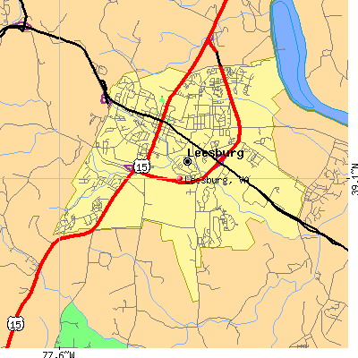
Map of Leesburg, Virginia, with the “cup” made by Highway 15. The black line is Route 7.
So I suppose one would think now that this is where I felt my Grail was hidden? Not quite. Because the Masonic Compass, on which I based the starting layout, looks more like the letter A than like a triangle. The triangle is only the top part of this shape, and the base of the triangle is the middle of the compass, it’s not the ending point.
The starting point of our compass here, its apex, lies in the town of Alexandria which word begins with the letter A. If that weren’t enough, the official abbreviation for the State of Virginia is “VA”, which symbols look like two opposing “compass legs” (superimposed they would of course look a lot like the Masonic "square n'compass" symbol). So it would seem that the “compass design” plays an important part both in the history of this state and in our particular Grail Story. I therefore decided that the "Leesburg Cup", at the mid-point of our compass, must be only pointing the Way to my Grail, it's not the actual hiding place itself.
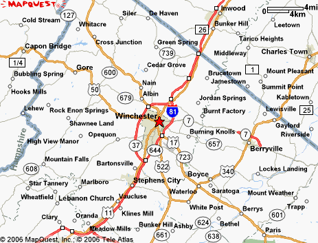
So I continued following westwards along both Highway 50 and Route 7, as the legs of our compass. And found that soon afterwards they both change angles, and then actually intersect each other. Their first intersection in the East was at Seven Corners as you recall. And their second (and last) intersection in the West is in the town of Winchester, Virginia, about twenty miles west of Leesburg, and about thirty-five miles west of Reston. The "straight line" of our Highway 50 started in Fair-chester. And now we have arrived at Win-chester.
Clickable map of roads in northern Virginia, showing the segment we followed from Alexandria to Winchester, enclosed by route 7 on top and HIghway 50 on the bottom
If you look at the area of Winchester on the map today, you will see that roads around also form a kind of a "bowl", this time on the western side of the city and facing eastwards (with the newer road I-81 now closing the circle, so it doesn't look like a bowl so much any more.) The "stem" of this "bowl" is our Highway 50, continuing west. And east of this "bowl" leads Route 7.
The “bowl” of Winchester. Highway 50 is the “stem”, going West from there.
I looked closer at the center of Winchester to see where the two roads meet, and saw that they basically flow into each other. They lie just a block apart right in the center of town (where Route 7 ends), and are connected there by US Highway 11. This is of course another most meaningful number consisting of two ones. It is even called "Cameron St." there, as if to give a further hint about its greater significance in our story by connecting it with our Baron. And Route 7 there is called "National Avenue" and then "Fairfax Lane".
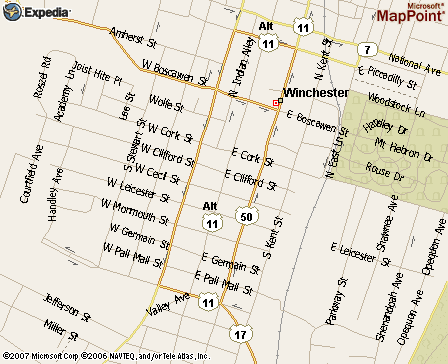
Map of downtown Winchester, showing the meeting place of Route 7 and US 50.
Winchester
Taking all of the preceding into the account, I decided that if my Grail was buried anywhere in Virginia at all - then Winchester simply MUST be the spot. But where exactly? To answer that, we have to take a much closer look at this town. For this we shall stop with the maps for a while, and get back to the regular history lesson.
One of the first things which showed me that I’m very much on the right track here, was a very interesting factoid I found about the Fairfax lands. It seems that Thomas Fairfax had to defend his Land Holdings from the claims of the Virginia government, which disputed the size of his estate (see “The Story of Virginia – an American Experience”.
Here's the relevant quote from the above website: "The long case ended in Fairfax's favor in 1745. He was declared sole owner of 5,282,000 acres, extending far west of the Northern Neck proper, to the region around Winchester, which was founded at this time." (Emphasis mine.)
The above account sounds pretty strange, to say the least. Why would a very rich man, the largest single landowner of the whole Virginia Territory, who already has over 5 MILLION acres of land in the area (for God's sake!) – WHY would such a man care if somebody wants to take some small part of it? Why should he bother getting involved in a lengthy and complicated court case to defend that portion? (And I just bet you that this court case revolved around my own earlier "problem" - the fact that Charles II was not the king in 1649, and thus could not make land grants at all.)
Well, evidently this small disputed part of the Fairfax lands had involved specifically the region of Winchester, seeing as somebody found it necessary to mention this particular town in the above otherwise general historical account. It would therefore be safe to guess that the area where the town was founded was particularly important to Thomas Fairfax for some reason.
And why was that - well, based on everything we said so far, most likely because he knew that this is precisely where the Grail was secreted by his predecessors in the Brotherhood. He wanted to be listed as owner of that land, because if it belonged to anybody else they could just start digging there anytime they wanted and possibly find his Secret. This he simply couldn’t allow.
It should be noted that although Winchester is just over twenty miles from Leesburg, it is located on the other side of the Blue Ridge Mountains, the old road leading through some treacherous mountain passes. The place was still very much wild in mid 17th Century. However, according to this historical website, various white traders, trappers and explorers were already coming through the area by 1650's, the years when I felt the Grail was brought from England. It is a possibility that in those days the Grail was buried in the "Cup of Leesburg" for a while, as its keepers waited for more Western territory to be won. But I have no doubt now that eventually the Grail went to Winchester.
The above site states that Thomas Fairfax himself came to live the remainder of his life just east of today's Winchester and south of the old road that became Highway 50. He moved there in the year 1749, exactly a hundred years after Charles I was executed in England - the event which caused the Grail to be moved to Virginia in the first place. Before moving to Winchester, Fairfax lived in Fort Belvoir, next to George Washington's home in Mount Vernon, and a short distance south on US 1 from today's Washington's Masonic Monument.
So Lord Fairfax basically followed the very same old road we mentioned - the "straight line" of Route 236 (Duke Street) and then Highway 50 - from his old home in Belvoir to the new one in Winchester. He moved exactly along the Marker which pointed to the location of the Grail.
Thomas Fairfax died in 1782, and his remains are entombed to this day in the yard of the Christ Episcopal Church, right at the very intersection of US Highways 50 and 11 in downtown Winchester on Boscawen St.
According to various sources, the area of Winchester was explored as early as 1606 by French Jesuits, resulting in a crude map of the area drawn by the famous explorer Samuel Champlain. The first serious white settlers started arriving only in the early 1700's, but by 1730 all the Indians had already been removed from the area.
Winchester was officially founded in 1738, first made up of four streets on the very same intersection of today’s Highways 50 and 11. The town was named after no less than the old Saxon Capital of England in Winchester in Hampshire, back from the magical pre-Norman days before the Royal Seat was moved to London by William the Conqueror.
Some years later in 1748, George Washington also came to live in Winchester, employed by Thomas Fairfax as the Surveyor of the region. From there Washington later pushed the frontier westwards of the Ohio River and beyond, where eventually the "Masonic City" of Cincinnati, Ohio was founded, right on the road which later became called our Highway 50.
This city was thusly named by the governor of the Northwest Territory, one Arthur St. Clair, of the famed St.Clair/Sinclair family, in honor of the obscure "Society of Cincinnati", of which he was a member. (You see what I mean about all these pertinent names... and an "Arthur" at that .) This secret society honored George Washington as a latter-day Cincinnatus, the Roman general who had saved Rome in a military victory and then just returned to his farm. The city of Cincinnati must somehow also be a most pertinent location, both on Highway 50 and on our Grail Quest - yet I did not explore that direction to the fullest either. Primarily because I do not think that the Grail itself actually went there - only the Society which was based on some of its precepts, or was perhaps even responsible for keeping its secret.
Washington’s Secret Revealed
And this is where I stumbled on a small discovery recently, which really clinched the whole scenario for me. Once again, it maybe just me though. (:-)
Remember that that my entire Grail Quest and the Reston Caper investigation was conducted only through the Internet, I never actually went to see any of these places. There’s no real need to do so any more, as much more information is available about them online than you could possibly find in situ. But despite its already huge size, the Internet is still a very new medium, with new websites and technologies being added on a daily basis. So although I searched for such things all over the place two and three years ago, this little bit of final evidence I found just two months ago in August of 2007, as I was publishing the Reston Caper and was looking for more images and documentation.
I stumbled on this very educational page, put up relatively recently by the Library of Congress - "George Washington: Surveyor and Mapmaker". Towards the middle of that page they have It has an extremely useful clickable map of the Northern Neck area in Virginia, which clever technology allows to be viewed from different angles and close-ups.
The inscription on the map reads:
“A survey of the northern neck of Virginia, being the lands belonging to the Rt. Honourable Thomas Lord Fairfax Baron Cameron, bounded by & within the Bay of Chesapoyocke and between the rivers Rappahannock and Potowmack: With the courses of the rivers Rappahannock and Potowmack, in Virginia, as surveyed according to order in the years 1736 & 1737.”
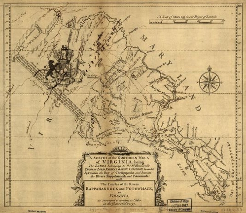
Map of the Fairfax Lands, 1730's
;;
In other words, this is a map of all the Fairfax Lands, and is thus basically our “Grail Map” for Virginia!
Here is a short recap of that story from the Virginia history books, as summarized on the above LoC website right next to this map. King Charles II of England had granted those lands to seven of his loyal supporters known as the Seven Barons. All the lands were eventually bought out by one of them, Baron Culpeper, whose daughter married Thomas Fairfax, the Fifth Baron of Cameron. Their son was the Fairfax we need, Thomas Fairfax Jr., the Sixth Baron of Cameron, (actually all his ancestors were named Thomas too, they evidently really liked that name.)
And as I have shown in earlier installments, the “Templar Grail” was brought from Scotland to Virginia by the Seven Barons during Cromwell’s Revolution sometime around the year 1650 and hidden somewhere on those lands. Thomas Fairfax, as the successor of the Barons to these lands, would've had to have been their successor in the Grail Legacy as well.
The above map was not made by George Washington himself (he was born in 1732), but is included on the page which talks about his work as a land-surveyor, because this is the land he started working on, when first employed by Thomas Fairfax in 1748 at the age of 16. This map must’ve formed the most important part of his job briefing by his patron and superior, and in fact young George gained his first experience in the field by accompanying Fairfax that year to survey the Winchester lands.
Note that only two places are marked with a Cross on this map – Winchester in the upper center, and the town of Cumberland in the upper left. Here’s a close-up which shows just the area from Alexandria to Cumberland, where the two crosses can be plainly seen:
Northern Neck area of the Thomas Fairfax lands, from Alexandria to Cumberland
Why should only these two locations be marked with these crosses on the large map, which shows many different places and settlements? Well, the likely answer that most would give, is that these were the two main Frontier Towns which were being settled in those times, the “hot spots” where land lots were being sold and thus paid special attention to. And indeed this may’ve been their cover story, sure. But seeing as I myself found these Two Crosses while following the Grail Trail, I have a much better explanation for them: they served to pinpoint the Grail’s hiding place for whoever succeeded Thomas Fairfax as the head of the Grail Brotherhood!
Now, see if you can repeat this trick I did. Locate the town of Alexandria, on the bottom right of the above map, just above the thick horizontal line which marks 39 degrees North Latitude. I put a protractor there and traced a straight line from Alexandria through the two crosses, Winchester to Cumberland - and got a precise 33 degree angle. That was certainly a fun thing to discover.
I think this proves it ladies and gentlemen. Even without that angle, the cross on Winchester would've certainly been enough for me after I had already determined the vital importance of this town. But if that weren't enough, then this obvious “Masonic” number of the 33 Degrees certainly clinched it.
You see, Thomas Fairfax died without siring children, and never actually had a son he could tell his secrets to. If he were indeed the head of the local "Grail Brotherhood", he would've needed to pass his charge to someone upon his death. And it is my contention that his Designated Heir for the “Virginia Grail Package” was no other than his young friend and apprentice - George Washington himself. That's why Fairfax gave him this map with the crosses marking his secret location.
Thomas Fairfax died in 1782 and was succeeded by his brother Robert Fairfax in England. The latter became the nominal owner of the Farifax lands in Virginia – but according to the Wiki article those lands were confiscated by the Revolutionary Government during the hostilities. Thus, very curiously bypassing ordinary inheritance laws, they basically passed right into Washington’s hands, to do anything he wanted with.
And I think this map proves that Washington knew about the Grail's location in Winchester. This is one of the few remaining hints they left to subsequent generations about the whole story of the Grail in Virginia. This is also the best example of something so important being hidden in plain sight. This map has been on public display for generations and everybody saw the two crosses, but never made the connection.
The Burial Ground
So where exactly was the Grail buried in Winchester? Well, in fact this doesn't really matter any more! Because in subsequent chapters I will try to show that the Grail is no longer there today, and will also try to explain why and when it needed to be moved again. But just out of sporting interest, I think I actually did find the place where it lay for a couple of centuries in Winchester. Except that the way I found it is very strange and would probably be largely unacceptable to most people. Yet it was plenty enough for me, when looking for something like the Grail.
See, I believe in the Absolute Possibilities of the Google Search Algorithm, after spending many years seeing it work what I can only call "Information Miracles". This is without any doubt the best research tool ever created in our world up to date. But in order to really utilize it, one has to know how to couple the Information Highway with the intuitive qualities of the mind. Then my “Holistic Detection” approach can be used to recognize the real leads when they appear.
So anyway, several months ago, almost two years after I had already concluded that Winchester was the Grail's resting place in Virginia, I happened to be looking for this very curious string in Google - "nine unknown gates". This is a highly mystical concept involving UFO's and high-ranking conspiracies and such, and the last thing I expected to see was a reference to Winchester in the top ten links - but there it suddenly was. The mention of those words in the linked article had nothing to do with the UFO conspiracy I was looking for at that moment. Instead I realized that this is showing me the precise Resting Place of the Grail in Winchester!
The link was to an article about the Winchester National Cemetery, founded in 1866, where the soldiers killed locally in the Civil War were buried. (If you take a look at that article, you'll see that it indeed has all the words from my string, "nine", "unknown", and "gates" - but not related to each other, just another fun coincidence.) The National Cemetery is located right in the center of Winchester, between our Route 7 ("National Avenue") and a very tiny "Charles St". And although I have absolutely no way of proving this, it is my contention based on all of the above, that this cemetery was erected precisely where the Grail was buried, in order to mask the spot.
But which grave in this cemetery? Well, that's easy. It's the only grave in any Military Cemetery where one can dig freely without "disturbing the dignity of the dead". The same place as in the famous movie "The Good, the Bad, and the Ugly" - the Grave of the Unknown Soldier, where there is never a body inside. Knowing this in theory is enough for me, and I don't need to actually go there and verify this.
One further interesting thing about Winchester - if you look at the official website of the Winchester Cemetery, you'll notice it says to contact the Culpeper National Cemetery for information. Well, seeing as "Culpeper" was the title of the original Seventh Baron who held the Charles II lands (his first name was also Thomas), I figured that this must somehow be important as well - maybe Fairfax and his people hid some clues or something in that town as well.
I looked at the town of Culpeper, which is located about 40 miles south-south-east of Winchester, accessible by US Highway 522. And I do not really understand the significance of this now - but there has to be some. Because the National Cemetery of Culpeper sits right on our US Highway 15 (which if you recall connected 50 and 7 between Aldie and Leesburg). And also, at that very place, US 15 is the same as US 29 - the road that later leads to the Model Town of Columbia, MD. The road leading east form Culpeper is Virginia Route 3 - a number which is probably as important as Virginia Route 7.
All this must be significant in our Tale as well, and it remains to find out how, another direction I had not yet followed. On the other hand, perhaps the town of Culpeper and the interestingly numbered roads leading to it could’ve well have been a fancy bit of misdirection on the part of The Grail Brotherhood to confuse would-be searchers and keep them from getting to Winchester. The only reason I myself happened to stumble on the “right trail” is because I was looking into something totally unrelated, that old Reston murder.
Where the Path Leads
Going back to Winchester however, I had become convinced for reasons which as noted will be elaborated later, that at a certain point the Grail had to be moved from there as well. Having decided this and because of those reasons, it seemed apparent that the only way for it to travel from there would be North, and if so - the only way to go would be by that highly interesting US Highway 11, which is called "Cameron Ave" in downtown Winchester and connects the two roads from Alexandria, Highway 50 and Route 7.
I followed Highway 11 from there all the way north, as it winds through the states of West Virginia, Maryland, Pennsylvania, and New York. Almost at its very end it reaches the town of Champlain, NY, right on the Canadian border. There it joins for the last few miles with another interestingly numbered highway, US 9. The Canadian road which leads north from Champlain is called "Canadian Highway 15" - another 15. More pertinently though, our Highway 11 ends just east of Champlain, in a location called Rouse's Point.
How about that! Didn't we start this journey so long ago with another "Rouse"? Very interesting. And the adjacent Lake Champlain, on the shores of which this town sits, is named after the same famous French Jesuit explorer Samuel Champlain, who if you recall from above, drew the original map of the Winchester region.
I decided that there simply has to be something more to all this, and followed the main road continuing Highway 11 east out of Rouses Point - this was US Highway 2, which crosses Lake Champlain into Vermont. It then goes further south and east into this state, and following along it I quickly came to the town of Richmond, Vermont, and soon afterwards Montpelier, Vermont. Both of which are also names of very significant places in Virginia, places I read about while studying the history of this state.
This led me to think that there probably exists some kind of a "mystical connection" between Virginia and Vermont. And having thought about it some more I became convinced of this. Because you see, Virginia and Vermont are abbreviated as VA and VT. And the letters "a" and "t" are the original first and last letters of the Hebrew Alphabet, which even today goes from Aleph to Tav, without the other letters added at the end by Greeks and Romans. Therefore, A and T would be (aside form the main US Communications Company) also the proverbial Alpha and Omega or A to Z - the beginning and the end. In the very same way in fact, in which our road began in Virginia, and ended in Vermont.
And an interesting corollary to the whole story, is the history of the Indian Nations from Virginia. The famous book “The Last of the Mohicans” by James Fennimore Cooper takes place around Lake Champlain, and involves the tribes of Iroquois and Delaware - two of the tribes which originally settled area of Virginia and the Delmarva Peninsula. So it appears that the Indians had followed that very same road north.
A further interesting addendum about the Virginia affair concerns myself personally. “VA” or rather AV were the initials of my father, Alexander Volkov. And the initials of my own name which I was given at birth are “VAV” (I had a Russian first name which I changed afterwards.) Funny how anything Russian would be somehow mirrored in Virginia. Additionally, recall the “straight line” of Highway 50. Between the towns of Chantilly and Aldie it passes right through the center of a little hamlet called “Lenah”, which is basically my mother’s first name. So now you really know how much I just love coincidences, hehe. But indeed, after all of that I do feel that for some reason I have some kind of a very weird mystical connection with the State of Virginia.
So that's basically it for now, in case anybody is still awake after all that information (I'm certainly not.) I bid you to seriously try and digest the foregoing, in case American History and Geography is your thing.
But cheer up even if you found it difficult to follow my line of reasoning - because our road by no means ends in Virginia, and not even in Vermont, oh no. Vermont is just another Important Marker on the way, but in fact we shall need to continue following US Highway 2 all the way east to where it ends and meets with US Highway 1 in a place called Houlton, Maine. Just across the border in New Brunswick, Canada, lies another town named Richmond. We shall not be stopping there though, and instead will take Highway 1 down south to Machias Bay and the little town of Jonesport, Maine, on the Atlantic coast again.
However that's a whole other story already.
But before I finally close this, another word about Winchester, England, the old English Capital. That town holds the famous Winchester Cathedral, according to the Wiki article possibly the only Cathedral in the world about which not one but two well-known songs were written.
One of them was the acclaimed hit "Cathedral", by Crosby, Stills, and Nash - a song I considered highly significant since first hearing it way back in the mid-seventies, because it deals with Good and Evil, killing in the name of God, and other philosophical issues. Well, I guess now I know why I thought it was so significant, hehe. Probably because it was a clue to the Grail itself, no less. So I would just like to close this part of our story with what I think you'll agree is a very pertinent quote from this song:
Now I'm standing on the grave of a soldier who died in seventeen ninety-nine,
And the day he died it was his birthday, and I noticed it was mine.
And my head didn't know just where I was, I was floating back in time.
Yes I am High, upon the Altar.
- from "Cathedral", by Crosby, Stills, and Nash
Seems like a fitting explanation as to why all this obsesses me so.
Sol