
Nazca Lines
From The Book of THoTH (Leaves of Wisdom)

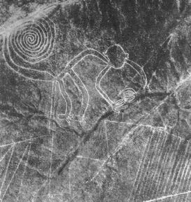
The Nazca Lines are gigantic geoglyphs located in the Nazca Desert, a high arid plateau that stretches 53 miles between the towns of Nazca and Palpa on the Pampas de Jumana. They were created by the Nazca culture between 200 BC and 600 AD. There are hundreds of individual figures, ranging in complexity from simple lines to stylized hummingbirds, spiders, monkeys, and lizards. The Nazca lines cannot be recognized as coherent figures except from the air. Since it is presumed the Nazca people could never have seen their work from this vantage point, there has been much speculation on the builders' abilities and motivations.
Contents |
Discovery
The conquistador chronicler Pedro de Cieza de León first mentioned some of the figures in 1547. He described the few glyphs drawn on hillsides whose shape can be seen without an aircraft.
The lines were first noticed in the modern era when airplanes began flying over the Peruvian desert in the 1920s. In 1927, Toribio Mejia Xespe, a Peruvian doctor and anthropologist was the first scientist to show interest in what he called these "great Incan ceremonial artifacts".
The first systematic and scientific survey of the lines began in the 1930s under the direction of Paul Kosok and Maria Reiche. Reiche took over the study in 1946 and until her death in 1998 lobbied to protect and preserve the lines. She lobbied successfully to have the lines declared a UNESCO World Heritage Site in 1995. Since then, improved aerial and satellite photography as well as increased interest and study of the glyphs and the surrounding desert has added to our knowledge of the site as well as the people who built it. For instance Cahuachi, a Nazca city overlooking some of the lines, was recently discovered in the surrounding hillside. It was built nearly 2,000 years ago and mysteriously abandoned 500 years later.
Building and Preserving the Lines

The lines were made by removing the iron oxide coated pebbles which cover the surface of the Nazca desert. When the gravel is removed, they contrast with the light-colored earth underneath. There are several hundred simple lines and geometric patterns on the Nazca plateau, as well as over seventy curvilinear animal, insect, and human figures. The area encompassing the lines is nearly 200 square miles, and the largest figures can be nearly 900 feet long. The lines persist due to the extremely dry, windless, and constant climate of the Nazca region. The Nazca desert is one of the driest on earth and maintains a temperature around 25°C (77°F). The lack of wind in the desert has helped keep the lines uncovered to the present day.
Theories
Accepted Explanation
Since their discovery, various theories have been proposed regarding the methods and motivations behind the lines' construction. The accepted archaeological theory is that the Nazca people made the lines using nothing but simple tools and surveying equipment. Wooden stakes in the ground at the end of some lines (which, coincidently, were used to date the figures) support this theory. Furthermore, Joe Nickell of the University of Kentucky has reproduced one of the figures using the technology available to the Nazca Indians of the time without aerial supervision. With careful planning and simple technologies, a small team of individuals could recreate even the largest figures within a 48 hour period. However, there is not much extant evidence concerning 'why' the figures were built, so the Nazca's motivation remains the lines' most persistent mystery. Most believe that their motivation was religious, making images that only gods could see clearly. The details of their theology, however, remain unsolved.

Alternative Theories
It has been proposed by some (for example Jim Woodmann) that the Nazcan lines presuppose some form of manned flight (in order to see them) and that a hot air balloon was the only possible available technology. Woodmann actually made a hot air balloon from materials and using techniques that would have been available to people at the time in order to test this hypothesis. The balloon flew (after a fashion) demonstrating that this hypothesis was possible, but there is no hard evidence either way.
Another theory contends that the lines are the remains of "walking temples," where a large group of worshipers walked along a preset pattern dedicated to a particular holy entity, similar to the practice of labyrinth walking. Residents of the local villages say the ancient Indians conducted rituals on these giant drawings to thank the gods and to ensure that water would continue to flow from the Andes. This take on the Nazca lines' purpose and importance is far more likely, as it correlates with the purposes of other North American geoglyphs. It also ties in with the extensive network of underground canals and waterways found dating from the same period.
Perhaps the most controversial theory was put forward by Erich von Däniken in 'Chariots of the Gods', who proposed that the lines were in fact landing strips for alien spacecraft. His argument is similar to Woodman's, claiming that the designs are so large and complex that they could only have been constructed using flying machines.
References
- Aveni, Anthony F. (ed.) (1990). The Lines of Nazca. American Philosophical Society, Philadelphia. ISBN 0871691833
- Bauer, Susan Wise (2001). The Story of the World, Vol. 1. Peace Hill Press. ISBN 0971412901
- Lambers, Karsten (2006). The Geoglyphs of Palpa, Peru: Documentation, Analysis, and Interpretation. Lindensoft Verlag, Aichwald/Germany. ISBN 3929290324
- Evil Star, Anthony Horowitz (2006)
External links
- Photogrammetric Reconstruction of the Geoglyphs of Nasca and Palpa
- Die Linien von Nazca und Frau Maria Reiche
- NASA Earth Observatory page
- Google Maps
- Nazca prehistoric balloon - Julian Nott and Jim Woodman's Nazca hot air balloon flight
- "The Nazca Lines Revisited: Creation of a Full-Sized Duplicate" - Joe Nickell's account of his reproduction
- Skeptic's Dictionary
- Nazca Lines by Antonio Gutierrez from "Geometry Step by Step from the Land of the Incas" (plays music)
- Nazca Lines site information
- Nazca Lines Photos of Nazca lines and figures by Georges Rosset
- Nazca Lines Information and Photos
- Nazca Lines, Mystery Park, Switzerland
Parts of this article are from the NASA Earth Observatory
Categories: Archaeological sites in Peru | World Heritage Sites in Peru | Geoglyphs

